Basic hydrology principles conclude that withdrawals from the Big Chino Valley will diminish the flow at Verde Springs in a one-to-one ratio. For example, if 1,000 afy of groundwater is removed from the basin, the flow from Verde Springs would eventually diminish by that amount. The average annual base flow over the lifetime of the Paulden gage is 17,900 acre-feet/year (afy), but due to the 20 year drought the current base flow is only 13,000 afy. The currently legally authorized groundwater transfers of 18,813 afy – without considering future demand from growth in the Big Chino and increased agricultural uses - will eventually dry up Verde Springs. Even though the WAC is no longer active, the NARGFM model is public domain, permitting the Citizens Water Advocacy Group to use this extremely valuable tool. CWAG consultants first evaluated the calibration and internal consistency of NARGFM, finding that the calibration is excellent and that the model is suitable for use as a predictive tool. Using a simplified scenario of 12,000 afy withdrawn from the BCWR and no mitigation, CWAG reports that pumping from the Big Chino Water Ranch (BCWR) will begin to diminish the base flow of the upper Verde River within a decade, and that the diminishment will grow with time. Salt River Project has also developed a groundwater model producing similar results. Studies and Experts agree: Withdrawing Groundwater from the Big Chino Valley Will Reduce Flow in the Verde River!
A 1993 study by the Bureau of Reclamation (BOR) concluded: “The findings of the study do not support a location in the Big Chino Valley where a large diversion of groundwater out of the valley would not result in a depletion of flows in the upper Verde River.”
There is no valid scientific basis to question the conclusion that unmitigated groundwater mining in the Big Chino Valley will eventually dewater the first 25 miles of the upper Verde River.
Updated December 19, 2018
The Yavapai County Water Advisory Committee (WAC) retained the US Geological Survey to develop the Northern Arizona Regional Groundwater Flow Model (NARGFM), a computerized simulation tool designed to project changes to groundwater levels and stream flow resulting from different water management scenarios. A scenario describes the location, time, and quantity of all water inputs and withdrawals from the aquifer. The model was published in 2011, generating controversy even in advance of publication. The BCWR partners have vigorously disputed and questioned the geologic data incorporated into the model and the scenarios.
As dissension grew the WAC became dysfunctional, causing the Yavapai County Board of Supervisors to dissolve the Committee.The resulting controversy prevented the WAC from using NARGFM to analyze several future scenarios for the Big Chino.
Updated December 19, 2018
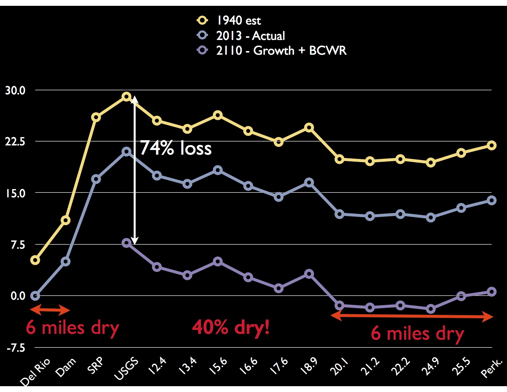
 This graph interprets CWAG’s modeling results. Moving downriver from the USGS Paulden stream gauge at mile 10, the flow from Verde Springs gradually declines until mile 25 at Perkinsville. The yellow line is an estimate of the river flow in 1940 prior to groundwater pumping. The grey-blue line represents the river flow on June 1, 2013 measured by Sierra Club Water Sentinel volunteers at intervals along the river. Note that the base flow at Verde Springs has already declined from the predevelopment flow of 29 cfs to 21 cfs due to historical groundwater pumping.
CWAG modeling results are the purple line, representing the flow in 2110 assuming: a) The BCWR begins pumping 12,000 afy in 2020 with no mitigation, b) population growth of 18% to 12,600 by 2050 (an extremely conservative estimate), c) recharge at 2005 levels, and d) flow conditions along the river as observed in 2013. This scenario projects that by 2110, six miles of river will be dewatered between mile 19 and 25. Also note that six miles of the upper River between Del Rio Springs and Verde Springs were dewatered decades ago.
We project that human groundwater pumping may dewater 6 additional miles of the upper Verde by 2110. One day without water is a very bad day for a fish.
Updated December 19, 2018
CWAG member John Zambrano has collated many studies by government agencies, experts, and scientists reporting on the connection between groundwater withdrawals and the base flow of the Verde. His whitepaper is 6 pages, non-technical, and can be viewed online.
Updated December 19, 2018
Groundwater Pumping Affects the River
At the 2009 hearings, Arizona Department of Water Resources (ADWR) Chief Hydrologist Frank Corkhill testified, referring to the pipeline only: “Prescott’s pumping from the Big Chino Sub-basin at some time will impact the flow of the Verde river unless there is mitigation, and that “the CODs {cone of depression} will capture groundwater that would have otherwise discharged at the Verde River Springs.”
Because groundwater moves slowly, there is a time delay between the onset of groundwater mining and observed reduction in spring flow. A computerized groundwater model can quantify the effects of groundwater pumping on base flow. Western water resource managers routinely use groundwater modeling to analyze management strategies.
